The Signs are Clear, Integration is Essential
New York, New York USA
Integration is essential for micromobility to be successfully embraced as a mainstream transportation option – and wayfinding must be central to that seamless connection, according to an international study by the Institute for Transportation and Development Policy (ITDP).
The international study, Maximizing Micromobility, was released in June and found cities can only realise the full benefits of micromobility options if they can successfully integrate them with other transport modes – particularly public transport.
“Integration between transportation modes enables cities to develop strong networks that prioritise pedestrians and public transportation, enable multimodal trips, and encourage mode shift away from private vehicles,” the study report says.
It says integrated mapping and wayfinding is at the heart of this synthesis, to ensure users can quickly and confidently connect their multimodal journeys.
“Informational integration focuses on providing users with clear, easily accessible information necessary for making multimodal trips,” according to the report.
“It helps users feel more comfortable relying on multiple transport modes because the information they need to make decisions about their trip is reliable, easy to understand and, potentially, housed in one place.”
Excellent Examples of Integration
The report highlights several examples around the world of effective information integration, including apps and other online wayfinding services.
“Mobile applications and QR codes show users different transportation options, routes, connections, and costs for a specific trip. These can be city-generated or provided by third parties, like Transit or Alipay,” it says.
In Argentina, the Buenos Aires city government operates a BA Como Llego app that enables users to see travel time, routes and service information for multiple modes, including train, metro, bus, bicycle, and walking. The app allows customisation that lets users set a maximum walking distance to reach their mode, set preferred trip characteristics and save preferred routes.
In Delhi, Uber’s BikeShare app offers users information about the Indian city’s motoshare, metro, and bus systems.
“Apps like these can promote more efficient trip planning that minimises travel time and creates more seamless connections between modes,” the report says.
The ability for data to be shared between service providers is critical for integrated information, particularly when private operators are responsible for providing modes of transportation, including bikeshare or scooter share.
“Publicly available real-time data that is standardised—as part of the General Bikeshare Feed Specification (GBFS), for example—enables mobile application developers to populate map apps with and generate routes using multiple modes or services. This makes it easier for users to locate different modes on a common map and make more informed decisions about their optimal route,” the Institute says.
More Cooperation Needed in Australia
The Director of Transport Innovation at Melbourne’s Institute for Sensible Transport, Dr Elliot Fishman, says a lack of coordination between transport operators in Australia has potentially been an obstacle to the introduction of similar multimodal apps in this country.
“Historically, there have been some good examples of working together, such as the shared ticketing system for public transport in Melbourne,” Dr Fishman said.
“The thing that’s really been lacking is an appreciation by government and transport operators of the importance of door-to-door journeys and planning.
“Increasingly, the world’s leading transport operators aren’t just thinking about the journey once passengers get to the station. For their customers, the journey begins the moment they leave their front door and doesn’t end until they arrive at their final destinations.
“For example, in the Netherlands they are benefitting from thinking more about the whole experience.”
Not surprisingly, bikes are the most popular option in the Netherlands to get to the train station. Up to 70% of train passengers use bikes to link to their train journey and surveys show they are more satisfied with their overall journey, compared to their fellow passengers.
Dr Fishman said this is at least partly because bikes and other forms of micromobility allow people greater freedom to time their journeys to coincide with train schedules and minimise the time they spend waiting for connections.
“This is further assisted by providing potential passengers with online, real-time information about any service delays and even how crowded the carriages are,” he said.
“In Australia, we still don’t even have any cities that have integrated bike paths with train stations, even though we’ve had train stations for over 100 years and we’ve been building bike paths for 30 years.”
He says train stations are an excellent example of how better integration of multimodal infrastructure and shared wayfinding information would generate a greater number of passengers for all forms of public transport and micromobility.
“The carparks at many Sydney train stations are full by 7.30 am, restricting the ability of other people to catch the train,” Dr Fishman added.
“While the response in Australia is to build bigger carparks, each space is typically occupied for several hours at a time and better options to get to the station by bike would enable many more people to use the train.”
Smarter infrastructure is complemented by wayfinding that provides times, maps, costs and other information in one convenient location.
“Internationally, the gold standard is services that enable people to plan and pay for their entire journey – across all modes of transport – using just one app. To the best of my knowledge, that does not exist anywhere in Australia,” he said.
“There is strong market demand, in Australia and overseas, for options that give people access to multiple modes of transport, rather than having to sign-up for individual services, particularly when they’re not sure how often they will use a new service.
“Places like France and the Netherlands have made it possible to jump from a bus or train to a bike using the same card.”
He said just making multimodal journeys easier to plan makes a big difference in the number of people likely to use them.
“It’s often a knowledge gap that causes people to default back to their usual form of transport, which is often travelling by car. Integrated mapping that clearly shows what transport options are available and how they connect will be a valuable incentive for many potential users.”
Traditional Signage
The ITDP study also celebrates international examples of traditional signage and wayfinding with effective integrated information.
Jakarta has prioritised and standardised wayfinding signage at transit hubs, directing travellers to commuter rail and van connections and is working to integrate its new bikeshare program into the wayfinding network.
Brazil’s metropolitan area of Rio de Janeiro has integrated maps in rapid transit stations that show users transfer options to other lines and other modes, including bikeshare and secure bicycle parking for personal micromobility. These maps also feature a QR code to online, real-time information that users can reference throughout their trip.
In the US city of Milwaukee, connections to bikeshare stations are announced onboard public buses. This can increase user comfort in unfamiliar locations and notifies passengers about available transportation options they might not have considered.
The Legible London wayfinding system, piloted in 2009, makes it easier for travellers to complete trips by walking, cycling, and using public transport. The system now has over 500 signs indicating walking distances to different destinations and transportation connections, such as metro, bus, and bikeshare. Additional signage highlights cycling infrastructure and the estimated ride times to encourage people to cycle.
Australian Guidelines
Sustainable transport consultant Warren Salomon said micromobility signage in Australia has been steadily improving in Australia since the release of an Austroads Bicycle Wayfinding report he produced and completed in 2015.
“Those guidelines have achieved a lot of progress in improving and standardising bike signage, so they are more easily spotted and followed,” Mr Salomon said.
“The report has also encouraged greater recognition of cycling as a mode of transport. It has assisted in the provision of signage that recognises that a rider’s journey doesn’t end when they leave the bike path, by providing clear directions to key destinations along the route and beyond the end of that path.
“The goal is to get the government to treat cycling as a complete system and create a network of bike signage comparable to Australia’s national network of road signage. You can start a car journey in much of Australia and be confident the familiar green and blue road signage will direct you all the way to your destination.”
He says an equally comprehensive network of micromobility signage is essential to encourage as many people as possible to travel by bike, rather than car. Each time a rider’s journey is interrupted by a lack of effective signage, it adds a disincentive for them to use a bike for future journeys.
“Equally, it is important that the signage comes hand in hand with high-standard infrastructure. It is just as frustrating for cyclists to follow signage to a destination, only to find the route includes having to ride on a busy road without a safe bicycle lane,” he explained.
“The Austroads guidelines were needed because we had such a fragmented system. We had the issue of getting the consistent standards adopted by each of the States and Territories, and then the State Governments say it is up to councils to decide what infrastructure is put in place.
“The Austroads guidelines also enable the provision of funding to be linked to the implementation of standardised signage, to further encourage greater consistency.
“We are steadily seeing more of the standardised blue and white bike directional signs but there is still plenty of room for improvement.
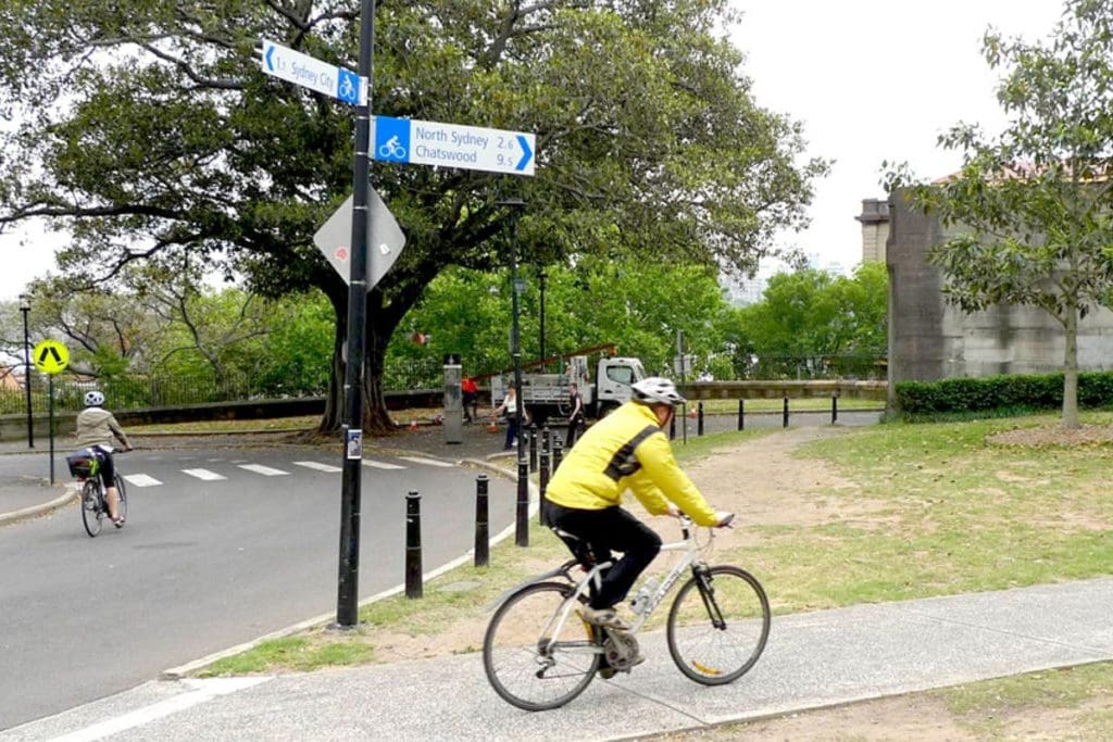
“The City of Sydney has become a posterchild of effective bicycle signage and wayfinding. It is recognising the importance of linking its bike paths and lane, including good signage and mapping, and many other councils are heading down the same path.”
Mr Salomon says the emergence of e-bikes is increasing the need for more complete cycling networks. Not only are e-bikes encouraging more people to ride, they’re enabling people to ride further. An easy-to-follow network of maps and signs is important to facilitate those longer journeys and further the momentum e-bikes are providing in getting people onto bikes.
He believes good physical signage will always be essential, despite advances in online mapping and wayfinding.
“The beauty of signs is they are part of your environment. You can see them from a distance and they are in your line of sight as your looking for other riders and pedestrians, as opposed to looking down at a screen,” he said.
“And while audio instructions work when you’re walking or in the enclosed environment of a car, when you’re riding you have the wind in your ears and you’re exposed to the weather.”
The ITDP report says COVID and the subsequent innovations implemented by many cities to create transport solutions have provided valuable momentum towards more permanent integration of transport options and associated information.
“Given the urgency cities have felt to install micromobility-supportive infrastructure and programs in response to the COVID-19 pandemic, now is a unique chance for cities to more explicitly integrate micromobility with other transport modes,” it says.